Showing posts with label Pendine Sands. Show all posts

Sunday, February 3, 2013

Starter for ten

The snow-covered cliff tops above Marros Sands
There’s nothing quite as exciting as starting a new project, be it a script, a diet or a walking book.


Last week, against a bleak and snowy backdrop, we started our on-the-ground research for Harri’s latest commission: a top 10 walks guidebook to complement his official Wales Coast Path book (Amroth to Swansea Marina)

The top 10 format has already proved a great success for its publisher, Northern Eye Books.

These beautifully designed little books cost just £4.99 and provide clear directions, Ordnance Survey maps, eye-grabbing panoramic photographs and interpretation of points of interest along the way.

Until recently only walks in the Lake District, Peak District and the Yorkshire Dales
were covered, however the good news is that publishers Carl Rogers and Tony Bowerman have decided to roll out the format to include circular walks along the Wales Coast Path. It’s a great idea and will hopefully encourage many more people to explore Wales’ beautiful coastline and nearby countryside.

Still on solid ground - the steps above Pendine 
First to be published in the Wales series was fellow Outdoor Writers Guild member Sioned Bannister’s offering on Cardigan Bay North (available direct from Northern Eye).  

Sioned is the OWG social media expert and she has written a great little book, which I know Harri and I are going to find extremely useful on future holidays. (And in the mean time, we can just enjoy looking at those gorgeous panoramic photographs.)

The snow had all but disappeared when we left Newport but, as we travelled along the M4 corridor, we could see it was a different picture further inland. We later learned that snow had caused widespread disruption in Carmarthenshire the previous day.

‘Do you think snow settles on sand?’ I pondered and, for once, my personal sage could not provide the answer.

There's nothing to beat sun, sea... and snow
There was an empty car park at Pendine and almost nobody about, but we duly paid our £3 parking charge and pulled on extra layers.

My heart sank when Harri headed past the seafront cafĂ© and towards the steps leading to the cliff top. Now perhaps it would be wise to check in advance what’s expected of me on any given walk, but strangely I always forget to ask pertinent questions like ‘where are we going?’ and Harri sensibly omits to mention words like ‘steep’ ‘mud-bath’ or ‘arduous’ in his pre-walk briefings.

The uphill section was actually fine. There was no ice underfoot and the view across the snow-covered Pendine Sands was spectacular. We trudged across the cliff top in crisp, clean snow, relishing the crunching underfoot and the snow-laden gorse bushes.

It was only when we began to descend to Morfa Bychan beach that things started to become a bit hairy. Mud, it would seem, doesn’t always dry out underneath snow but, when the temperature isn't low enough, lies there oozing and squelchy, ready to send the unsuspecting hiker sliding down the mountainside on their backside. I tiptoed along, envisioning my fate, concerned about doing more damage to an already dodgy right foot, begging Harri to turn back.

Of course, we didn’t because Harri has a book to write and we must walk every inch of every walk – even those which are ultimately rejected. Instead, we headed straight up the opposite cliff, towards Marros Sands

One of Carmarthenshire's churned up fields,
 temporarily covered by snow
I’ve written about this section of the Wales Coast Path several times already so I’m not going to repeat myself. Suffice to say, it’s not pleasant when conditions are wet… and, once again, they were.

A short distance inland and the walking conditions immediately improved, lifting my spirits.

The village of Marros boasts a camping site, a church and an unusual war memorial, modelled on nearby Neolithic tombs. We lunched briefly on the stone benches in the church porch, but it was too cold to linger and we were soon on our way again.

The final stretch of the walk was stunning scenery-wise, however I struggled to get warm again. As we descended into a wooden valley, we came across a stunning log cabin, presumably a holiday let in the warmer months.

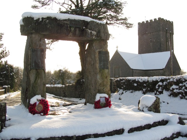
The Marros war memorial and church
At low tide, it’s possible to walk from Marros Sands to Pendine along the beach but the timing wasn’t right for us so we walked up an old cobbled path and emerged at the top of Pendine.

The day was closing in, but it seemed too early to head to our functional Travelodge room, so we decided to warm ourselves in Spring Well public house. For anyone who doesn’t know it, the Spring Well is the sort of pub every village/small town should have –  friendly if slightly eccentric locals willing to entertain passing strangers, a heavenly log-burning fire, ginger wine, but best of all, its very own kitler.

This walk may or may not make the final ten but seeing Stella the cat twitching her little grey moustache made the day's cold and muddy conditions worthwhile.

Stella has no idea why she attracts so much attention

Sunday, October 28, 2012

Wales Coast Path: Beachcomber's Cut Part 1


Pendine Sands - a vital stretch of the Wales Coast Path
Nearly two months after completing Harri’s guidebook for the official Wales Coast Path, we were still pondering some of the bizarre route choices, specifically why so many of Wales’ best beaches have been completely bypassed.

Anyway, Harri’s publishers, Northern Eye, were more than happy for him to suggest ‘alternative’ routes where he felt the official route wasn’t particularly scenic (or anywhere near the coast), which is how we found ourselves heading back to the Carmarthenshire stretch yesterday.

The first beach we were planning to ‘reveal’ to would-be Wales coastal hikerswas Pendine. Now there is a very good reason why this seven-mile beach is closed to the public sometimes. During WW2, it was acquired by the Ministry of Defence and most of the beach is still used as a firing range from Monday to Friday.

An MOD watch tower 
At weekends, however, there is no logical reason for the long Wales Coast Path detour along the busy Pendine to Laugharne road. We’ve walked this route three times, twice out and once back, and believe me, it sucks. Anyone expecting a coastal walk will be sorely disappointed as the open sea remains hidden behind swathes of MOD land and views of the estuary only become visible towards the end.

Harri’s plan this weekend was to investigate the more scenic route along Pendine Sands and find out if it was possible to head inland at Ginst Point to reach Sir John’s Hill (which later links to Dylan Thomas’s Birthday Walk ).

As you enter the beach at Pendine, there are signs warning of the dangers of unexploded munitions, but if the red flag is not flying, visitors are permitted to stroll along the firm, sandy beach, for miles if they so wish.


Ripples of sand at low tide
On a bitterly cold but gloriously sunny October morning, we set off to uncover the delights of this magnificent beach, the location for many land speed records.

At the Pendine end, we were surrounded by dog walkers, family groups, holidaymakers, outdoor enthusiasts, even runners with dogs, but gradually, as we clocked up the miles, the people fell away until it was just Harri and me, and a vast expanse of sand, sea and sky.

At low tide, Pendine is a beachcomber’s paradise. As we headed east the sea was barely visible. The hard, damp sand was strewn with shells, driftwood and plastic bottles. We passed the remains of a tree, decorated with garish detritus, presumably by passers-by, a heavy wooden door, numerous oil drums and frequently, bundles of hay woven with knotted nets.

The detritus tree adds a splash of colour to the beach
At Ginst Point, there was good news. After leaving the beach we joined a gravel track leading to two car parks and then walked along the old sea wall embankment, enjoying views across the estuary towards Llansteffan Castle and the old ferry crossing point.

We retraced our steps, which is usually very boring but with the tide in, the beach was transformed and we walked along the water’s edge, me looking for shells and Harri just enjoying the late afternoon sunshine.

Today’s walk took a little longer than usual, mainly because I was experimenting with my new Canon Compact camera. The crisp, cold weather was perfect for landscape photography but it didn’t mean I couldn’t have a little fun with the various settings (my current favourites are monochrome and vivid colours).

Discovering the delights of monochrome

We timed the end of our 18-mile walk perfectly and were just arriving back at Pendine village (too tired even to stop at the pub) as the sun was setting behind the hills of distant Pembrokeshire.

As I pondered which setting to use for that all-important sunset photograph, Harri reminded me that today’s walk had fulfilled all my criteria for the perfect hike: it was coastal, flat, there was no mud and, most important of all, the sun had shone all day.

I agree. It was the perfect hike along a magnificent stretch of sand – so why don’t coast path officials want you to walk it?


Just one of my many sunset photographs 

Friday, September 23, 2011

Conquering coast paths

The seven-mile stretch of sands at Pendine

My brother-in-law, Paul, a keen hiker and passionate about the great outdoors, has always hated coastal walking, preferring instead to head for Wales’ more mountainous regions – the Brecon Beacons, Snowdonia et al.

Not me.  Given the option of an amble over the Black Mountains or a tough trek along the Welsh coastline, I’d opt for the latter everytime.  And yes, you did read that right, because as anyone who has done some serious coast path walking will confirm, there’s nothing tougher on the old legs than all those sea level to cliff top climbs – done over and over again in quick succession.

Anyway, with two proposed trips to the Rhinogs rained off in the past month and last weekend’s plans threatening to go the same way, we decided instead to enjoy the best walking this lush land has to offer in south, rather than north, Wales.

And with the launch of the Wales Coast Path looming ever closer (May 5th 2012), we thought it would be exciting to visit the Carmarthenshire stretch of this new national trail and find out how much progress had been made in waymarking the route.

No more mud, just nice solid boardwalks
Welsh readers will know that the official Pembrokeshire Coast Path ends at Amroth.  When we completed the 186-mile trial in January 2008, we were enjoying ourselves so much we decided to carry on to Pendine Sands (best known as the location of five land speed records between 1924-7). Unfortunately, almost as soon as we crossed the Pembrokeshire border, the path, no longer official or well-trod, deteriorated dramatically, with the absolute low point, a steep climb through thick, wet, squelchy mud from Marros Sands to the cliff-top above (I hate mud!).

I’m delighted to report that said mud is now a thing of the past and, in its place, there are nice solid boardwalks (I love boardwalks!).  So a big thank you to Carmarthenshire Council for sorting out this stretch of path well ahead of May 2012.

While the Council’s coast path officer may be diligent, there’s little he or she can do about the sheer amount of climbing on this short but spectacular section of path (Amroth to Pendine).  It probably didn’t help that we did an out and back walk, creating a sinking realisation (for me at least) that every knee-aching descent was going to become an even tougher ascent when we turned around and did the whole route in reverse.

It’s worth the effort though. The views from the top of those cliffs are amazing – Worm’s Head in one direction and Caldey Island, Tenby and Saundersfoot, in the other.

An active rain cloud heads in our direction 
It goes without saying that we got rained on, but Carmarthenshire coastal rain isn’t quite as wet or horizontal as Rhinog rain (or so Harri insisted), and there is a nice pub at Amroth (the New Inn) where you can sip your favourite tipple for however long it takes for the rainbow to appear.

Ah, Welsh pubs and the characters who prop up their bars – now that’s a subject for a whole new blog.